Early Formation of Long-Distance Exchange Networks
The Silk Road did not originate as a single, deliberately constructed route, nor was it conceived as a unified system by any one state or empire. Instead, it emerged through a gradual process of integration among pre-existing regional exchange networks that had developed independently across Eurasia. By the late first millennium BCE, a series of interconnected corridors linked China, Central Asia, Persia, and the Mediterranean, forming a diffuse but functional system of long-distance interaction. These connections were not inevitable; they were contingent on ecological adaptation, political expansion, and the cumulative decisions of merchants, pastoralists, and states.
Geography imposed significant constraints on the structure of these networks. The vast deserts of Inner Asia, particularly the Taklamakan and Gobi, limited direct traversal and necessitated reliance on oasis chains. Meanwhile, formidable mountain systems such as the Tian Shan, Kunlun, and Pamir ranges fragmented movement into narrow corridors and seasonal passes. These environmental realities created predictable pathways that facilitated repeated use over time. Settlements that could sustain water sources—whether through rivers, underground channels, or glacial melt—became indispensable nodes within an otherwise inhospitable landscape.
The consolidation of these networks accelerated under the Han Dynasty (206 BCE–220 CE), whose westward expansion into the Gansu Corridor marked a decisive shift in Eurasian connectivity. The corridor functioned as a strategic bottleneck linking the Yellow River basin to the Tarim Basin. Its control allowed Han authorities to project influence into Central Asia, not by replacing existing systems but by integrating into them. Diplomatic missions, especially those led by Zhang Qian in the 2nd century BCE, revealed to the Han court that regions far beyond their western frontier already maintained sophisticated trade relationships.
Zhang Qian’s reports did not create transcontinental trade but provided knowledge that allowed Chinese producers and officials to participate more directly in it. His descriptions of powerful Central Asian polities, including the Yuezhi and the Greco-Bactrian kingdoms, demonstrated that China was not at the edge of civilization but rather adjacent to an expansive network. This realization encouraged policies that supported trade, military outposts, and diplomatic engagement along these routes.
The Geography of Actual Routes
Modern representations of the Silk Road often depict a single continuous line stretching from East Asia to the Mediterranean. In reality, the system consisted of multiple, shifting corridors that adapted to environmental conditions, political circumstances, and market demands. These routes evolved over time, and their precise configuration could change within a single generation.
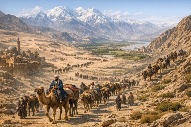
One of the most important geographic features shaping the Silk Road was the Taklamakan Desert, an arid basin surrounded by mountain ranges. Rather than crossing the desert directly, caravans traveled along its periphery, forming two principal routes. The northern route passed through Turfan, Kucha, and the Ili Valley. This route connected more readily with степpe networks, where nomadic groups enabled faster, long-distance movement. The ecology of the степpe, characterized by open grasslands, facilitated horse-based transportation, which could be more efficient than camel caravans in certain conditions.
The southern route skirted the desert along a line of oasis cities including Khotan, Yarkand, and Niya. These settlements depended on river systems descending from the Kunlun Mountains, creating pockets of agriculture and urban life. While slower than степpe routes, the southern path offered greater reliability due to established infrastructure and predictable water sources.
Beyond the Tarim Basin, routes converged in major Central Asian centers such as Samarkand, Bactra (Balkh), and Merv. These cities functioned not merely as transit points but as sites of economic transformation. Goods were repackaged, taxed, exchanged, and sometimes substantially altered through local craftsmanship. Samarkand, for example, became renowned for its role in the distribution of luxury goods and later for papermaking techniques introduced from China.
From these hubs, routes extended toward the Iranian plateau, moving through territories controlled at various times by Parthian and Sasanian authorities. Further west, connections reached urban markets in Mesopotamia and the eastern Mediterranean, including cities under Roman and later Byzantine influence. In parallel, maritime extensions of the Silk Road connected to the Indian Ocean trade network. Goods could move from inland Central Asia to ports along the Persian Gulf or the western coast of India, where they entered sea routes linking East Africa, Arabia, South Asia, and Southeast Asia.
This combination of overland and maritime systems created redundancy. When political instability or environmental disruption affected one corridor, others could compensate. As a result, the Silk Road should be understood not as a fixed infrastructure but as a dynamic network capable of reconfiguration.
Who Used the Routes
Trade along the Silk Road was rarely conducted over its entire length by a single group of merchants. Instead, commodities moved in stages, passing through the hands of multiple intermediaries. Each segment of the journey was typically managed by local traders who possessed knowledge of regional conditions, languages, and political structures.
Among the most prominent of these intermediaries were the Sogdians, an Iranian-speaking people based in Central Asia. Between the 4th and 8th centuries CE, Sogdian merchants played a crucial role in facilitating exchange across Eurasia. Their commercial success derived from several factors, including their widespread diaspora communities, adaptability to different cultural environments, and multilingual capabilities. Sogdian settlements have been identified from China to the Black Sea, indicating the extent of their influence.
Nomadic groups also occupied a central, though often misunderstood, position within the Silk Road system. Commonly characterized in historical sources as raiders, степpe societies in fact provided essential services. They supplied horses, transport expertise, and military protection, and in some cases they maintained political stability across vast territories. Confederations such as the Xiongnu, Turkic Khaganates, and later the Mongols exerted control over степpe routes, enabling or restricting movement depending on their strategic interests.
Empires that governed sedentary regions also played a regulatory role. The Kushan Empire, for instance, controlled key segments linking South Asia to Central Asia, facilitating the movement of goods and cultural influences, including Buddhism. The Sasanian Empire, which dominated much of the Iranian plateau, managed trade between Central Asia and the Roman world, often acting as both intermediary and gatekeeper.
Religious communities and pilgrims were additional users of these routes. Buddhist monks traveled from India to China, carrying texts and iconographic traditions. Christian missionaries of the Nestorian tradition, as well as Manichaean adherents, moved across similar pathways. These movements were not incidental to trade but were embedded within the same logistical frameworks.
Goods and Motivations
Although silk remains the most iconic commodity associated with these networks, it was only one among many goods traded across Eurasia. Caravans transported textiles, spices, precious metals, glassware, ceramics, horses, and semi-precious stones. The diversity of goods reflected regional specializations. China exported silk and lacquerware; India contributed spices and textiles; Central Asia supplied horses and jade; the Mediterranean regions produced glass and metalwork.
The significance of these exchanges extended beyond material commodities. The Silk Road facilitated the transmission of technologies, artistic styles, and intellectual traditions. Papermaking, for example, spread westward from China, eventually transforming administrative and scholarly practices in the Islamic world and later in Europe. Similarly, artistic motifs reveal a blending of Hellenistic, Persian, and East Asian influences, particularly in regions such as Gandhara.
Religion constituted one of the most important forms of intangible exchange. Buddhism spread from the Indian subcontinent into Central Asia and China, adapting to local contexts along the way. Monasteries often served as rest stops for travelers, reinforcing the integration of spiritual and commercial networks. Other religious traditions, including Zoroastrianism and early forms of Christianity, also moved along these routes.
The motivations for participation were therefore complex. Economic profit was a primary driver, but it was accompanied by diplomatic, strategic, and intellectual objectives. States used trade missions to gather intelligence on distant regions. Tribute exchanges between empires often overlapped with commercial activity. In some cases, the symbolic value of exotic goods exceeded their practical utility, serving as markers of status or tools of political negotiation.
Instability and Adaptation
The Silk Road’s functionality depended heavily on political conditions. Periods of fragmentation, warfare, or shifting alliances could disrupt established routes, forcing merchants to adapt. For instance, conflicts in Central Asia sometimes redirected trade toward maritime pathways, increasing the relative importance of seaborne commerce.
Conversely, the consolidation of large empires often facilitated long-distance exchange by providing security and standardized regulations. The Mongol Empire in the 13th and 14th centuries represents a notable example. By unifying vast territories under a single राजनीतिक structure, the Mongols created conditions that reduced barriers to movement. The system of relay stations, known as the Yam network, allowed for relatively rapid communication and travel across Eurasia.
This period, sometimes referred to as the “Pax Mongolica”, saw increased interaction between Europe and East Asia. Travelers such as Marco Polo benefited from the relative stability of the routes. However, this stability was contingent and ultimately temporary. The fragmentation of Mongol authority, combined with the impact of pandemics such as the Black Death, contributed to the decline of overland trade in subsequent centuries.
Environmental factors also played a role in shaping adaptability. Changes in climate could affect water availability in oasis regions, altering the viability of certain routes. Similarly, technological developments in shipbuilding and navigation gradually shifted the balance toward maritime trade, particularly from the late medieval period onward.
Implications for the Modern “New Silk Road”
Contemporary discourse surrounding the Silk Road has been revitalized by initiatives such as China’s Belt and Road Initiative (BRI). This project seeks to develop infrastructure networks linking Asia, Europe, and Africa through railways, highways, pipelines, and maritime corridors. While the terminology invokes historical precedent, the comparison must be approached with caution.
The historical Silk Road was decentralized, adaptive, and driven by a diverse array of actors. It evolved organically over centuries, shaped by local conditions and incremental decisions. In contrast, the BRI represents a coordinated, state-led effort supported by significant financial investment and strategic planning. Its scale and institutional framework differ fundamentally from the loosely connected systems of the past.
Nevertheless, certain continuities are evident. Modern infrastructure routes often follow similar geographic логics, connecting regions that have historically functioned as نقاط of exchange. Central Asia, once again, occupies a కీలு position as a transit zone between major economic centers. Projects targeting rail connectivity across Kazakhstan, pipelines through Xinjiang, and port development in the Indian Ocean echo earlier patterns of linkage between الإنتاج and consumption regions.
Geopolitical considerations remain central. Just as historical trade routes were influenced by imperial rivalries and alliances, modern corridors are shaped by competition among states and regional blocs. Issues of debt sustainability, sovereignty, and security intersect with economic objectives. Infrastructure projects can enhance connectivity, but they can also create dependencies or exacerbate tensions.
Another important distinction lies in the technological and आर्थिक context. Contemporary supply chains operate at speeds and scales unimaginable in premodern times. Digital communication, containerization, and financial systems have transformed the nature of trade. Yet, despite these changes, the الأساسي principle remains: long-distance exchange is inseparable from political power and geographic constraint.
The invocation of the Silk Road in modern policy discourse serves not only as a historical reference but also as a narrative tool. It frames contemporary المشاريع as a পুনা continuation of a shared Eurasian heritage. However, the historical record suggests that the original Silk Road was less a unified المشروع and more a complex النظام of تعاملات among diverse actors.
Understanding this distinction is crucial for تحلیل current developments. The past does not provide a direct blueprint for the present, but it offers insight into the interplay between geography, commerce, and political authority.
For further reference on Central Asian trade networks and archaeological findings, see Silk Road Foundation and The Metropolitan Museum of Art Heilbrunn Timeline.