Environmental Constraints and Route Selection
Caravans on the Silk Road operated within strict environmental limits that shaped not only the paths they followed but the broader structure of interregional exchange. Contrary to modern assumptions that trade gravitates toward the shortest distance, historical routes across Eurasia prioritized water availability, access to pasture, and predictable political conditions. The resulting network was not a single road but a shifting lattice of pathways calibrated to ecological realities.
In arid environments such as the Taklamakan Desert, which remains one of the largest shifting-sand deserts in the world, mobility was constrained by extreme temperature fluctuations, minimal precipitation, and the absence of reliable surface water. As a result, long-distance traffic divided into two main corridors—the northern and southern rims of the Tarim Basin. Each of these routes connected chains of oasis settlements, such as Turfan and Kucha in the north, and Khotan and Yarkand in the south. These oases were sustained by glacial meltwater descending from surrounding mountain ranges and functioned as indispensable nodes for rest, provisioning, and exchange.
The spacing of these settlements was not arbitrary. Caravans typically traveled distances that could be covered in several days without exhausting water supplies or overburdening animals. This imposed a rhythm on trade, effectively segmenting long journeys into manageable stages. In many cases, the viability of an entire route depended on the maintenance of a few critical water points. When wells failed or political control over an oasis changed, traffic could shift dramatically, illustrating the sensitivity of the system to localized disruptions.
In mountainous regions such as the Pamirs, Tianshan, and Hindu Kush, routes were further constrained by topography. Rather than crossing ranges directly, caravans followed river valleys that provided gentler gradients, access to water, and forage for animals. Seasonal passes determined the temporal dimension of route selection. Certain corridors were open only during late spring to early autumn, when snow levels were sufficiently low and river crossings manageable. Even then, the timing of passage required careful coordination, as early thaw could produce hazardous flooding.
The knowledge required to navigate these conditions was cumulative and socially transmitted. Merchant families, caravan leaders, and local guides preserved and adapted route information across generations. Unlike maritime navigation, which increasingly relied on standardized charts, overland trade depended heavily on experiential knowledge. Mapping existed in some form, but it was often schematic and secondary to lived familiarity with terrain, climate patterns, and political conditions. This reliance on human memory and social networks made the Silk Road both resilient and vulnerable: resilient in its capacity to adapt, vulnerable in its dependence on localized expertise.
Logistics of Caravan Movement
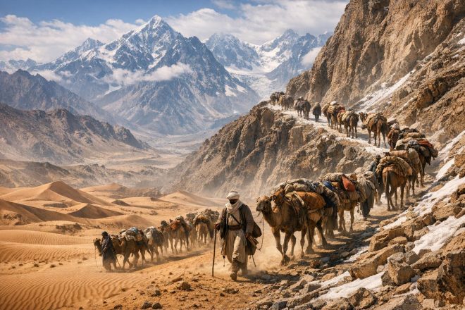
A caravan along the Silk Road functioned as a mobile system of coordinated labor, capital, and environmental adaptation. Its organization reflected a careful balance between efficiency and risk mitigation. The selection of pack animals was one of the most consequential logistical decisions, as different species were suited to distinct ecological zones. Bactrian camels, with their thick fur and ability to withstand cold and arid climates, dominated in Central Asian deserts and steppe regions. Their capacity to carry heavy loads over long distances made them indispensable for bulk trade. In contrast, dromedary camels were more common in the hotter, drier regions to the west, particularly in Iranian and Arabian landscapes. In mountainous terrain, mules, horses, and yaks were preferred for their sure-footedness and adaptability to steep ascents.
Load management was critical. A camel might carry between 150 and 200 kilograms, distributed evenly to prevent injury and fatigue. Overloading could result in early loss of animals, which had cascading effects on the viability of the caravan. Loss of even a small percentage of animals could reduce carrying capacity below the threshold needed to sustain the journey economically. For this reason, caravans often included spare animals and supplies, accepting short-term inefficiencies to ensure long-term survival.
Movement followed a structured daily routine shaped by environmental conditions. Travel typically began before sunrise, when temperatures were lower and animals were more capable of sustained effort. A midday توقف allowed both humans and animals to rest during peak heat, particularly in desert regions where overheating posed a significant risk. Movement resumed in the late afternoon and continued until dusk. Night travel was less common but not unknown, especially in cases where moonlight and cooler temperatures offered advantages.
Caravans varied in size, from small groups of a few dozen animals to large convoys numbering in the hundreds. Larger caravans provided increased security and logistical redundancy but required more complex coordination and access to larger resource pools at each توقف. Smaller caravans were more flexible and could navigate narrower routes but were more vulnerable to attack and environmental hazards.
Caravanserais played a central role in sustaining these movements. These fortified inns were spaced at relatively regular intervals along major routes, particularly in regions under stable political control. They offered water, food, shelter, and a measure of security for merchants and animals. Architecturally, caravanserais were designed to accommodate both humans and livestock, often enclosing a central courtyard with rooms lining the perimeter. Some were state-funded, reflecting an interest in facilitating trade and collecting taxes, while others were established through private patronage or religious foundations. Their distribution provides a material record of trade intensity and political priorities, with denser networks corresponding to periods of relative stability and economic integration.
Desert Navigation Techniques
Desert navigation along the Silk Road required an integration of observational skill, environmental knowledge, and accumulated experience. In landscapes where shifting sands could obscure paths within hours, reliance on fixed trails was impractical. Instead, caravan leaders employed astronomical observation, using the position of stars to maintain direction during both night travel and early morning departures. Knowledge of constellations and seasonal star movement was essential, particularly in featureless stretches where landmarks were scarce.
During daylight, navigation relied on a combination of visual cues and environmental indicators. Caravan guides recognized distinctive geological formations, such as isolated rock outcrops or changes in soil color. Wind patterns also provided orientation, as prevailing winds shaped dune alignments that could be read like a map. However, these indicators were not static, and their interpretation required experience.
Water management remained the central logistical concern in desert crossings. Wells and cisterns were maintained along established routes, often under the control of local authorities or communities who derived economic benefit from passing caravans. Access to these water sources could be regulated, taxed, or restricted, making control over them a significant form of power. In some regions, underground channels such as qanats supplemented surface water, enabling the development of oases in otherwise inhospitable environments.
Caravans carried supplementary water in animal skins or ceramic containers, but this imposed a trade-off. Every unit of water transported reduced the space available for commercial goods. This constraint influenced the type of goods traded, favoring high-value, low-bulk commodities such as silk, spices, precious metals, and manuscripts. Bulk goods were more commonly traded over shorter distances or via maritime routes when available.
The role of local guides cannot be overstated. These individuals possessed detailed, location-specific knowledge that could not be easily codified. They understood seasonal variations in water availability, recent changes in terrain, and the political dynamics of the regions traversed. Their services were often indispensable, particularly for caravans entering unfamiliar territories. The reliance on such expertise underscores the extent to which Silk Road trade depended on human networks as much as physical infrastructure.
Crossing Mountain Passes
Mountain crossings represented some of the most hazardous segments of Silk Road travel. The Pamirs, often referred to as the “Roof of the World,” along with the Tianshan and other ranges, imposed severe constraints on movement. Elevations frequently exceeded 4,000 meters, where reduced oxygen levels posed risks of hypoxia for both humans and animals. Symptoms such as fatigue, dizziness, and disorientation could impair decision-making and slow progress, increasing exposure to other hazards.
Terrain further complicated movement. Narrow paths along steep slopes limited the size of caravans and required careful management of spacing to prevent accidents. Loose الصخور and sudden weather changes added to the risk. Snowstorms could occur even in months typically considered passable, while avalanches posed a constant threat in certain مناطق. These conditions necessitated a reduction in load size, as heavily burdened animals were more prone to سقوط or exhaustion.
Timing was therefore critical. Caravans aimed to cross high passes during windows of relative stability, typically in late spring or early summer. However, these windows could vary from year to year, requiring flexible planning. Early crossings risked encountering deep snow, while late crossings increased the likelihood of storms and deteriorating conditions.
River crossings presented additional challenges. Glacial melt in warmer months caused rivers to swell, sometimes rendering established crossing points impassable. In these cases, caravans were forced to wait, seek alternative routes, or construct temporary solutions. Delays had economic implications, as extended travel times increased costs and risk.
Political authorities recognized the strategic importance of these chokepoints. Control over key passes allowed states to regulate trade, collect tolls, and exert influence over transregional movement. In some cases, rulers invested in maintaining pathways or providing limited الأمن, though the extent and reliability of such efforts varied. The concentration of control in these narrow corridors meant that shifts in political power could have disproportionate effects on the broader network of exchange.
Security and Political Factors
Security was a persistent concern for caravans, and it intersected closely with political conditions along the Silk Road. Banditry, local conflicts, and fluctuations in state control posed ongoing risks. Caravans adopted multiple strategies to mitigate these threats, including traveling in larger groups, hiring armed guards, and negotiating safe passage with local authorities through tribute or taxation.
The level of risk varied significantly across time and space. Regions under strong centralized control tended to offer greater امنیت for trade, as states had an interest in protecting economic activity that generated revenue. The Han Dynasty in China and the Sasanian Empire in Persia both developed administrative systems that facilitated trade while extracting taxes. These systems included patrols, checkpoints, and the maintenance of infrastructure such as roads and caravanserais.
The Mongol period marked a notable phase of relative stability across much of Eurasia. The establishment of a vast, contiguous empire reduced the number of political boundaries and enabled a more standardized system of governance over trade routes. Merchants could access a network of relay stations, often referred to as the yam system, which provided fresh animals, supplies, and official protection. Passports or official documents allowed for more regulated and predictable movement. While not eliminating risk, this system lowered barriers to long-distance exchange and contributed to an increase in transcontinental interaction.
However, this stability was contingent on the cohesion of the empire. As Mongol political unity fragmented, security conditions deteriorated in some regions. This cyclical pattern—where periods of integration facilitated trade, followed by fragmentation and increased risk—recurs throughout Silk Road history.
Local power structures also played a significant role. In many مناطق, control was exercised by tribal groups or semi-autonomous communities that could either facilitate or disrupt trade. Their cooperation was often secured through negotiated arrangements rather than coercive force. This reliance on decentralized actors highlights the complexity of governance along the Silk Road, where authority was layered and often overlapping.
Continuities in the Modern “New Silk Road”
Contemporary efforts to recreate or expand trans-Eurasian connectivity, particularly through China’s Belt and Road Initiative, reveal both continuities and transformations relative to historical patterns. Despite advances in engineering and transportation technology, modern infrastructure remains influenced by terrain, climate, and political geography. Railways, highways, and pipelines frequently follow corridors that parallel historical routes, especially in regions where natural constraints limit alternatives.
In Central Asia and western China, mountain ranges and desert basins continue to channel movement along specific pathways. The same passes that guided caravans now host tunnels, रेल lines, and highways. While modern technology allows for greater تجاوز of environmental barriers, such projects require significant investment and ongoing maintenance, underscoring that geography still imposes costs and constraints.
Political factors, however, have become more explicit and institutionalized. Modern states regulate borders through formalized systems of customs, visas, and trade agreements. Infrastructure projects are often embedded in broader geopolitical strategies, reflecting concerns over energy security, market access, and regional influence. The negotiation of these projects involves multiple actors, including national governments, international organizations, and private कंपनियाँ.
At the same time, the challenges of coordination remain reminiscent of earlier periods. Infrastructure alone does not guarantee connectivity. Effective operation requires stable governance, transparent regulations, and cooperation among diverse stakeholders. Disruptions—whether from political instability, economic tensions, or environmental factors—can still affect the flow of goods.
The historical experience of the Silk Road suggests that successful long-distance trade depends on the alignment of environmental feasibility and political cooperation. The persistence of these underlying dynamics, despite significant technological change, highlights the enduring relevance of geography and governance in shaping patterns of exchange across Eurasia.