Mountain Passes and the Structure of Trans-Eurasian Trade
Trade between China and Central Asia was shaped less by formal political boundaries than by the physical realities imposed by terrain. Across Inner Asia, the mountain systems of the Tianshan, Pamir, and Kunlun did not merely complicate movement; they defined it. These ranges created an environment in which mobility was channeled into a limited number of viable corridors. Movement across Eurasia was therefore not a matter of open choice but of constrained pathways. Caravans, envoys, pilgrims, and military detachments all depended on narrow valleys and high-altitude passes that functioned as enduring conduits for exchange.
These corridors were embedded within a broader environmental system anchored by deserts, steppe lands, and alpine zones. The distribution of water, pasture, and shelter determined not only where travel was possible but where it was sustainable. Over time, the repetition of travel along certain routes consolidated them into recognizable arteries of exchange. These arteries, often retrospectively labeled as parts of the “Silk Road,” were in reality complex and shifting networks tied intimately to ecological limits. Mountain passes acted as the hinges between distinct ecological zones, linking agrarian civilizations to pastoral societies and integrating disparate regional economies.
The resulting pattern of connectivity was uneven but highly structured. Rather than facilitating generalized movement across space, the terrain concentrated activity into predictable routes. This concentration had profound implications. It increased the strategic value of specific locations, amplified the economic significance of intermediary communities, and imposed rhythms on trade that reflected seasonal and climatic cycles. The Silk Road system, often imagined as a sprawling and diffuse network, was in practice highly dependent on a relatively small number of critical passageways.
Geography as a Constraint and an Opportunity
At the center of this system lay the Tarim Basin, a vast depression ringed by mountains and dominated by the Taklamakan Desert. This basin functioned both as a barrier and as a funnel. While the desert itself was largely impassable, its perimeter offered two principal routes: a northern track running along the foothills of the Tianshan and a southern track skirting the Kunlun range. These routes were not interchangeable. Each was shaped by distinct ecological conditions, political alignments, and access points into adjoining regions.
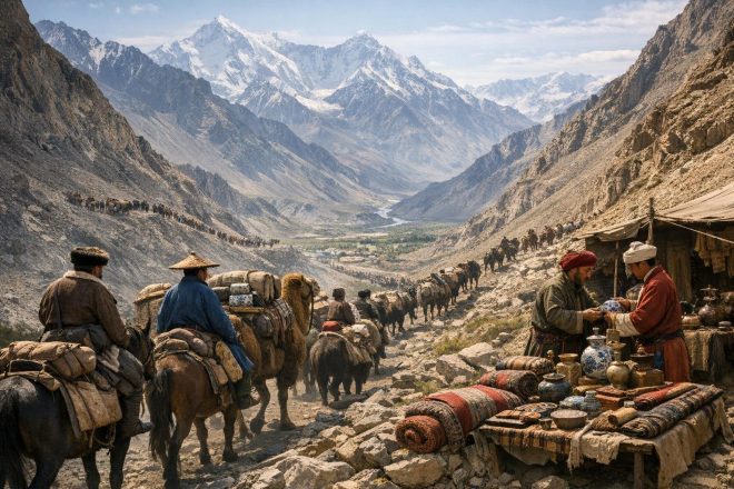
The mountain passes connecting the Tarim Basin to Central Asia were critical nodes within this system. Passes such as the Bedel and Torugart facilitated access to the Ferghana Valley, a region of considerable agricultural productivity and political importance. From there, connections extended westward toward Sogdia, Bactria, and beyond. In the opposite direction, routes linked the basin to the Hexi Corridor, providing access to the Chinese heartland.
Geography imposed clear constraints. High-altitude passes were subject to extreme weather, including heavy snowfall, strong winds, and sudden temperature shifts. These conditions limited the periods during which travel was feasible. Caravans often had to wait for favorable conditions, resulting in a trade system that operated in seasonal cycles rather than continuous flows. The timing of departures was calibrated to avoid winter closures and to align with the availability of pasture and water along the route.
At the same time, geography created opportunities. The very constraints that limited movement also concentrated it, enabling the emergence of stable trade hubs. Oasis cities such as Kashgar, Khotan, and Turfan flourished precisely because they occupied positions at the intersection of major routes. Their prosperity depended on their ability to support and regulate the flow of caravans moving through constrained corridors. These cities became centers of commerce, administration, and cultural exchange, reflecting the interplay between environmental limitation and economic opportunity.
The concept of geography as both constraint and opportunity is essential for understanding the Silk Road. The mountain passes did not merely restrict movement; they structured it in ways that facilitated long-distance exchange under specific conditions. By channeling traffic through predictable routes, they made sustained interaction across vast distances possible, even in a challenging environment.
Political Control and Strategic Bottlenecks
The concentration of movement through mountain passes created what can be described as strategic bottlenecks. These were locations where relatively small groups could exert disproportionate influence over trans-regional exchange. Control over such bottlenecks conferred economic benefits in the form of tolls, taxation, and trade regulation, as well as strategic advantages related to security and diplomacy.
During the Han dynasty, Chinese expansion into the Western Regions was motivated in part by the desire to secure these corridors. The establishment of administrative outposts and military garrisons in the Tarim Basin reflected an effort to stabilize the routes against interference from nomadic groups, particularly the Xiongnu. Control over the passes and adjacent oases enabled the Han state to facilitate the movement of goods such as silk while ensuring access to valuable imports, including horses from Central Asia.
The Tang dynasty further developed this approach by institutionalizing a network of garrisons and protectorates. These installations were not uniformly effective, and control often fluctuated, but they represented a sustained attempt to anchor political authority in geographically strategic locations. The interplay between imperial states and local polities was complex. Oasis kingdoms retained varying degrees of autonomy while participating in broader systems of tribute and trade.
Nomadic confederations also played a critical role. Their mobility and familiarity with steppe and mountain environments allowed them to influence trade routes, either by providing protection or by disrupting movement. Political authority in Central Asia was rarely stable, and shifts in power frequently altered the accessibility of key passes. This fluidity contributed to the dynamic nature of Silk Road trade, as merchants adapted to changing political landscapes.
The Mongol Empire represented a significant departure from this pattern. By consolidating vast territories across Eurasia, the Mongols reduced fragmentation and enhanced the predictability of long-distance trade. The system often described as the Pax Mongolica did not eliminate the challenges posed by geography, but it mitigated many of the political risks associated with travel. Mountain passes remained difficult to traverse, but the likelihood of encountering hostile forces or arbitrary tolls decreased under centralized authority.
Despite these periods of consolidation, control over strategic bottlenecks was rarely permanent. Political authority in the region was inherently decentralized, and local actors often retained significant influence. This persistent fragmentation meant that the economic significance of mountain passes was closely tied to ongoing negotiations of power rather than fixed territorial boundaries.
Technological and Logistical Adaptations
The challenges posed by mountain environments necessitated a range of technological and logistical adaptations. These adaptations were not static; they evolved in response to changing conditions, new forms of knowledge, and the demands of expanding trade networks.
Pack animals were central to this system. Bactrian camels, with their ability to endure cold temperatures and carry substantial loads, were particularly well-suited to the conditions of Central Asia. In higher altitudes, yaks and certain breeds of horses provided more reliable transport. The selection of animals was closely tied to the specific characteristics of each route, including elevation, terrain, and climate.
Caravan organization reflected an awareness of risk management. Goods were distributed across multiple animals to minimize potential losses. Caravans traveled in groups large enough to provide mutual support but small enough to navigate narrow and difficult paths. Leadership within caravans was typically entrusted to individuals with extensive knowledge of the terrain and the political conditions along the route.
Infrastructure played a supporting role. Caravanserais, located at intervals along major routes, provided shelter, food, and opportunities for trade. These establishments were particularly important near the approaches to mountain passes, where caravans needed to prepare for difficult crossings. In some cases, states or local authorities invested in maintaining paths, bridges, and waystations, recognizing their importance for both economic activity and administrative control.
Equally important was the accumulation of environmental knowledge. Local guides possessed detailed understanding of seasonal patterns, water sources, and potential hazards such as avalanches and landslides. This knowledge was often transmitted orally and remained concentrated within specific communities. The reliance on local expertise reinforced the role of intermediaries in facilitating long-distance trade.
Navigation techniques combined practical experience with rudimentary tools. While maps in the modern sense were limited, travelers relied on established markers, oral descriptions, and shared knowledge networks. The predictability of routes, enforced by geography, allowed for the gradual accumulation of reliable information even in the absence of formal cartographic systems.
These adaptations collectively enabled the sustained use of mountain passes despite their inherent difficulties. They illustrate how human systems adjusted to environmental constraints, transforming potential barriers into functional components of a broader network of exchange.
Economic Effects of Route Selection
Decisions regarding route selection were shaped by a complex interplay of factors, including distance, safety, political conditions, and cost. High-altitude passes offered shorter routes but carried greater जोखिम in terms of weather and terrain. Lower passes, while more accessible, often extended travel time and exposed caravans to different forms of political or environmental risk.
Traders had to evaluate these factors carefully. The choice of route could significantly affect the profitability of a journey. Higher risks necessitated higher potential returns, while more stable routes supported consistent but potentially lower margins. These calculations were not static; they shifted in response to changing conditions.
As a result, trade flows were dynamic. When a particular corridor became unstable due to conflict or environmental disruption, traffic often shifted to alternative routes. Such shifts had direct consequences for the communities located along these paths. Cities and towns that were once central to trade could decline rapidly if routes bypassed them, while previously marginal locations could experience sudden growth.
Archaeological evidence from sites such as Khotan and Kashgar illustrates these patterns. Periods of prosperity are often associated with secure and active trade routes, while phases of decline correspond to disruptions or rerouting. Material remains, including coinage, ceramics, and infrastructure, provide insight into the fluctuating fortunes of these settlements.
The economic effects extended beyond individual cities. Regional patterns of production and specialization were influenced by access to trade routes. Areas connected to major corridors could integrate into wider exchange networks, producing goods for distant markets. Conversely, regions outside these networks remained more localized in their economic orientation.
The role of taxation and toll collection further shaped economic behavior. States and local authorities often imposed fees on caravans passing through their territories. While such fees could generate revenue, excessive or unpredictable taxation could deter traders and redirect traffic elsewhere. This created incentives for authorities to balance revenue extraction with the need to maintain competitive and reliable routes.
Continuity into the Modern Period
The structural importance of mountain corridors has persisted into the modern era, even as the technologies of transportation and communication have transformed. Contemporary infrastructure projects often align closely with historical routes, reflecting the enduring influence of geography on patterns of connectivity.
Modern roads and railways have been constructed along corridors that were once traversed by caravans. Passes such as Khunjerab, now integrated into highway systems, illustrate this continuity. While the scale and speed of movement have increased dramatically, the underlying logic remains similar. Movement is still channeled through specific passages determined by terrain.
The Belt and Road Initiative represents a major effort to expand and modernize trans-Eurasian connectivity. Many of its projects follow historical pathways, adapting them to contemporary requirements. Investments in tunnels, bridges, and upgraded roads aim to reduce the constraints imposed by geography, but they do not eliminate them. The selection of routes continues to be shaped by the same fundamental considerations that influenced ancient trade.
Geopolitics plays a significant role in determining which corridors are prioritized. Borders, customs regimes, and diplomatic relationships affect the feasibility and attractiveness of different routes. Just as in the past, control over key passages can confer strategic advantages. Modern states, like their historical counterparts, seek to secure and regulate these corridors to advance economic and political objectives.
Technological advancements have altered the nature of risk. Weather forecasting, improved engineering, and advanced vehicles have reduced some of the challenges associated with mountain travel. However, other forms of जोखिम have emerged, including geopolitical tensions and infrastructure vulnerabilities. The balance between efficiency, security, and cost remains central to route selection.
Conclusion
Mountain passes have played a foundational role in structuring trans-Eurasian trade. Their significance derives from their function as both constraints and enablers of movement. By channeling activity into specific corridors, they created a network that was at once limited in its pathways and expansive in its reach.
The historical development of the Silk Road cannot be understood without recognizing the centrality of these geographic features. They influenced the location of cities, the distribution of economic activity, and the strategies of political actors. Their impact extended across centuries, shaping patterns of exchange that linked distant regions.
Despite changes in technology and political organization, the fundamental dynamics associated with mountain passes persist. Modern infrastructure continues to reflect the constraints imposed by terrain, and contemporary geopolitics echoes earlier struggles for control over strategic bottlenecks.
In this sense, mountain passes represent a form of continuity within a changing world. They are enduring elements in the landscape of Eurasian connectivity, shaping the movement of goods, people, and ideas across time.