Geography and Environmental Constraints
The safety of Silk Road routes was fundamentally conditioned by geography, not merely as a backdrop to movement but as a dynamic force that structured decision-making, seasonal timing, and risk calculation. The Eurasian landmass presents a highly varied environmental matrix, including arid basins, high mountain systems, temperate steppes, and riverine corridors. Merchants, caravan leaders, and state authorities all had to adapt to this variability. Routes that minimized exposure to ecological extremes generally emerged as more sustainable and, by extension, safer over the long term.
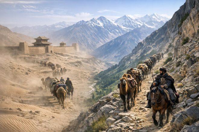
The Taklamakan Desert, often described in historical sources as a place from which one does not return, exemplifies the dangers inherent to poorly chosen routes. Shifting sand dunes, limited water sources, and extreme temperature variability made direct crossings exceptionally hazardous. As a result, most Silk Road traffic skirted the desert along its northern and southern peripheries. The northern route followed the foothills of the Tian Shan mountains, while the southern route traced the edge of the Kunlun range. These corridors allowed caravans to access meltwater streams descending from the mountains, creating a chain of oasis settlements such as Turpan, Kucha, and Khotan. These oases functioned not only as logistical waypoints but also as micro-centers of governance and cultural exchange.
Similarly, the Gobi Desert posed a different, though equally significant, set of challenges. Its gravel plains and sparse vegetation made navigation difficult, and the lack of consistent landmarks increased the risk of disorientation. Caravans traversing this region often relied on experienced guides and carefully timed journeys that aligned with seasonal patterns. Safer routes in this context were those that intersected with known water points or followed established tracks reinforced by repeated use over generations.
River valleys provided natural corridors that reduced risk. The Amu Darya and Syr Darya basins, for instance, supported agricultural settlements and urban centers that facilitated trade. These waterways also offered relatively predictable routes that minimized navigational uncertainty. However, proximity to water did not eliminate danger; flooding, shifting channels, and political competition over fertile land could introduce additional risks. Nevertheless, compared to arid or mountainous alternatives, riverine pathways generally supported higher volumes of sustained traffic.
Mountain systems such as the Pamirs and the Tian Shan introduced a different dimension of environmental constraint. High-altitude passes were often snowbound for significant portions of the year, restricting travel to narrow seasonal windows. Avalanches, landslides, and altitude-related health risks further complicated crossings. Yet these routes were sometimes preferred despite their difficulty because they offered strategic advantages. They could bypass politically unstable lowland regions or reduce exposure to banditry in densely trafficked areas. Thus, safety was not synonymous with ease; rather, it reflected a balance between environmental hazards and human threats.
Climate variability also played a role in determining route safety over time. Periods of increased aridity or colder temperatures could render previously viable routes untenable. Archaeological evidence from abandoned settlements in the Tarim Basin suggests that shifts in water availability forced rerouting and, in some cases, the collapse of local trade nodes. Merchants and states had to remain adaptable, continuously reassessing the viability of established pathways in response to changing environmental conditions.
In this context, the safest routes were not fixed but evolved in response to ecological and climatic pressures. The interplay between geography and human adaptation created a dynamic system in which knowledge, experience, and institutional support were as critical as physical terrain. Understanding these environmental constraints is essential to interpreting the broader patterns of Silk Road connectivity.
Political Stability and Imperial Control
While geography established the baseline conditions for movement, political structures determined whether trade could proceed with relative predictability. Strong imperial systems often provided the institutional framework necessary to reduce uncertainty. The Han Dynasty, for example, invested in military outposts and administrative control in the Hexi Corridor, a narrow but crucial passage connecting the Chinese heartland to Central Asia. By securing this corridor, the Han state not only protected trade routes but also integrated them into a broader imperial strategy that linked economic exchange with diplomatic and military objectives.
During the Tang Dynasty, this approach was further refined. The Tang court maintained garrisons in key oasis states and established tributary relationships that extended its influence deep into Central Asia. This network of alliances and direct control created a relatively stable environment in which merchants could operate. The presence of imperial authority reduced the likelihood of arbitrary interference and facilitated dispute resolution, both of which were essential for long-distance trade.
The Mongol Empire represents one of the most significant examples of how political unification could transform route safety. The establishment of what is often termed the Pax Mongolica in the 13th and 14th centuries created an unprecedented level of continuity across Eurasia. Under Mongol rule, a system of relay stations known as the yam enabled rapid communication and movement. These stations provided fresh horses, provisions, and protection, effectively reducing the risks associated with long-distance travel. Merchants operating under Mongol-issued passports, or paiza, were granted safe passage and access to these facilities.
However, the relationship between imperial control and safety was not uniformly positive. Empires could impose heavy taxation or requisition resources, increasing costs for merchants. Moreover, the collapse of centralized authority often resulted in a rapid deterioration of security conditions. The fragmentation of the Mongol Empire into competing khanates led to the reemergence of border controls, increased tariffs, and localized conflicts. In such environments, routes that had previously been secure could become dangerous within a relatively short period.
Political fragmentation introduced additional complexities. In regions where authority was divided among multiple actors, including tribal confederations, city-states, and small kingdoms, merchants had to navigate a patchwork of regulations and risks. Banditry tended to increase in these contexts, not only as a result of weak enforcement but also because competing authorities sometimes used informal predation as a means of revenue generation. Consequently, the safety of a route often depended on the ability of merchants to negotiate passage through multiple jurisdictions.
Diplomacy played a crucial role in mitigating these challenges. Trade agreements, marriage alliances, and tribute systems helped stabilize relations between neighboring polities. In many cases, the flow of goods was closely tied to political legitimacy, with rulers seeking to demonstrate their capacity to facilitate commerce. Thus, the safety of Silk Road routes must be understood as a function of both coercive power and negotiated order.
Infrastructure and Caravanserai Networks
Infrastructure served as the physical manifestation of political will and economic necessity. Among the most গুরুত্বপূর্ণ elements of this infrastructure were caravanserais, which provided essential services to travelers. These roadside complexes typically included enclosed courtyards, storage facilities, sleeping quarters, and water sources. Their design reflected the need for both सुरक्षा and efficiency, offering protection from environmental exposure and human threats.
The distribution of caravanserais along major routes created a structured rhythm of travel. Caravans could plan their journeys around predictable stopping points, reducing uncertainty and fatigue. This regularity also facilitated the exchange of information, as merchants shared news about road conditions, political developments, and market opportunities. In this sense, caravanserais functioned as nodes within a broader المعلومات network, enhancing both safety and economic coordination.
Persian territories were particularly notable for their investment in such infrastructure. Successive dynasties recognized the strategic value of facilitating trade and constructed extensive networks of caravanserais across their domains. These facilities were often linked to state-sponsored road systems, which included markers, wells, and maintenance regimes. The cumulative effect of these investments was to create corridors that were not only physically navigable but also institutionally supported.
Urban centers complemented these roadside facilities. Cities such as Samarkand, Bukhara, and Merv served as major التجاري hubs where goods were exchanged, taxed, and redistributed. The الأمن of these المدن was critical to the overall functioning of the Silk Road. Fortifications, policing, and administrative oversight all contributed to creating an environment in which merchants could operate with a degree of confidence.
Infrastructure also extended to financial practices. Systems of credit, bills of exchange, and partnerships reduced the need for merchants to carry large quantities of physical currency, thereby lowering the risk of theft. While these mechanisms varied across regions, their presence was closely linked to the وجود of stable and развит commercial institutions. In this way, infrastructure encompassed both physical and institutional dimensions, each reinforcing the other.
Local Alliances and Commercial Organization
Beyond imperial structures and physical infrastructure, the safety of Silk Road travel depended heavily on local relationships. Merchants rarely operated in isolation; instead, they relied on networks of intermediaries, guides, and protectors who possessed localized knowledge and influence. These relationships were often formalized through agreements that specified terms of passage, payment, and protection.
Tribal groups played a particularly important role in certain क्षेत्रों, especially in steppe and شبه-arid zones where state control was limited. These groups could either facilitate or hinder trade, depending on the nature of their interactions with merchants and states. In many cases, caravans negotiated safe passage through the payment of tolls or the provision of goods. Such arrangements were pragmatic, reflecting a recognition of the सीमाएँ of centralized authority.
The Sogdian merchants provide a notable example of how commercial organization could enhance safety. Originating from the region of present-day Uzbekistan and Tajikistan, the Sogdians established extensive торговые networks that spanned much of the Silk Road. Their communities were often embedded within key നഗര and oasis cities, creating a web of взаимосвязанные торговые relationships. This नेटवर्क facilitated trust, reduced transaction costs, and provided a درجة of mutual protection.
Merchant associations and caravans themselves functioned as коллектив security mechanisms. By traveling in groups, traders could pool resources to hire guards, share provisions, and respond collectively to threats. The scale of a caravan often correlated with its सुरक्षा, as larger groups were less vulnerable to нападения. However, larger caravans also required more coordination and could attract внимание, illustrating the trade-offs inherent in different organizational forms.
Religious and культурные institutions also played a role in shaping networks of trust. Buddhist monasteries, Islamic waqf institutions, and other धार्मिक establishments often provided lodging, mediation services, and financial support. These institutions were embedded within broader social systems that transcended राजनीतिक boundaries, contributing to a sense of continuity and reliability along certain routes.
Economic Density and Route Competition
The مستوى of economic activity along a given route significantly influenced its safety profile. Heavily trafficked routes tended to benefit from регуляр maintenance, increased oversight, and the presence of complementary services. These factors created a feedback loop in which higher traffic encouraged further investment, which in turn attracted more traders. Over time, such routes became institutionalized as primary arteries of exchange.
However, economic density also introduced potential vulnerabilities. Concentrations of wealth could attract organized criminal activity or even state-sponsored expropriation. In some cases, local authorities imposed high tariffs or engaged in monopolistic practices, increasing the cost of التجارة. Merchants had to weigh these factors against the सुरक्षा provided by well-established routes.
Less frequented routes offered an alternative, particularly during periods of political instability. By avoiding contested regions, these pathways could reduce exposure to conflict. However, they also lacked the support systems associated with अधिक established corridors. The absence of infrastructure, limited access to information, and reduced возможности for collective action made such routes inherently riskier over the long term.
Competition between routes was a постоян feature of the Silk Road system. Changes in political السيطرة, environmental conditions, or technological capabilities could shift the balance of advantage from one corridor to another. For example, the rise of maritime التجارة in the Indian Ocean gradually reduced the أهمية of overland routes, particularly for bulk goods. Nevertheless, land-based التجارة remained significant for high-value items and for regions not easily accessible by sea.
This प्रतिस्पर्धा underscores the adaptability of Silk Road التجارة networks. Rather than a single मार्ग, the Silk Road functioned as a مجموعة of interconnected pathways that evolved in response to changing conditions. Safety, in this context, was a relative and context-dependent concept, shaped by the interplay of economic incentives and जोखिम management strategies.
Implications for the Modern “New Silk Road”
Contemporary initiatives often referred to as the “New Silk Road,” most notably China’s Belt and Road Initiative (BRI), reflect both continuity and परिवर्तन in the factors that shaped historical Silk Road routes. While modern technology has mitigated many of the environmental challenges associated with long-distance travel, geography still influences the लागत and feasibility of infrastructure مشاريع. Mountain ranges, deserts, and राजनीतिक boundaries continue to shape the مسیر of railways, pipelines, and highways.
Political stability remains a central determinant of route सुरक्षा. Large-scale infrastructure investments require long time horizons and significant capital commitments, making them sensitive to political risk. Countries participating in BRI projects often negotiate bilateral or multilateral agreements that address issues of security, regulation, and वित्त. The success of these projects depends not only on physical construction but also on the क्षमता of participating states to maintain stable governance environments.
Infrastructure development under the BRI echoes historical precedents in its emphasis on connectivity. Investments in ports, railways, and logistics hubs aim to create integrated corridors that facilitate trade. These projects often include provisions for industrial zones and economic clusters, reflecting a broader दृष्टिकोण that links infrastructure with regional development. However, the scale and complexity of modern systems introduce new challenges, including debt sustainability, environmental impact, and geopolitical competition.
Local alliances and stakeholder engagement continue to play a महत्वपूर्ण role. Infrastructure projects frequently intersect with local communities, requiring negotiation and adaptation. Social and राजनीतिक dynamics at the स्थानीय स्तर can influence the सफलता or failure of projects, much as they did in historical contexts. The need for inclusive governance and transparent processes is increasingly recognized as a critical component of long-term sustainability.
Economic density remains a निर्णायक factor in determining the viability of routes. Corridors that connect major production and consumption centers are more likely to attract sustained traffic and investment. At the same time, competition between routes persists, with देशों and regions seeking to position themselves as key nodes within global trade networks. This competition is shaped by a combination of geographic advantage, policy frameworks, and institutional capacity.
In contrast to the historical Silk Road, modern connectivity operates within a global النظام characterized by rapid communication, digital التجارة, and complex supply chains. These developments have reduced some traditional risks while introducing new forms of vulnerability, including cyber threats and systemic disruptions. Nevertheless, the الأساسية dynamics of geography, politics, infrastructure, and economic organization continue to shape the सुरक्षा and efficiency of long-distance trade routes.
Understanding the historical Silk Road provides valuable insights into these contemporary processes. The factors that once determined the safety of caravans—environmental constraints, political stability, infrastructure, local relationships, and economic density—remain relevant, albeit in transformed ways. By examining these continuities and changes, it becomes possible to better assess the opportunities and challenges associated with modern प्रयास to recreate or reimagine Eurasian connectivity.